Register now or log in to join your professional community.

<p>How do you be the future by living in a dream and imagine your future faithful - First you love the dream and the power of love and the power of persuasion its insistence to achieve whatever challenges - just Xi at the beginning of a difficult but insist to achieve the target action shall be upon reality - Give me information Thanks to everyone -- عصام السبع esam elsbe</p>
In the defense and intelligence communities, CADRG and CIB data are two of the most common sources of basemap data. Mosaic datasets make it much easier to store, manage, and use these raster products. If you are responsible for making CADRG and CIB data available to users within your organization, then this blog will be of interest to you; I’ll be pointing out some key concepts and tips for storing CADRG and CIB in mosaic datasets.
Creating a mosaic datasetFirst, you will need to create a new mosaic dataset within a geodatabase, which you can do using the Create Mosaic Dataset tool. 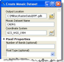 This tool only requires three pieces of information from you:
In most cases you’re ready to run the tool after you’ve specified these.
The coordinate system of a mosaic dataset can be different from the coordinate system of the source data (CADRG and CIB data use WGS 1984). If it is different, then ArcGIS will project the source data on-the-fly to match the coordinate system of the mosaic dataset.
In some (rare) cases you might specify pixel properties for the mosaic dataset, though generally you won’t need to. If you don’t specify these values when the mosaic dataset is created, they will be defined based on the properties of the first raster added to the mosaic dataset. For CADRG and CIB data (single-band rasters with a color map) this will be 3-band/8-bit unsigned; the mosaic dataset framework maps CADRG and CIB data to 3 bands.
To display CADRG data correctly, the mosaic dataset must always be defined as 3-band; for storing CIB data, you could define the mosaic dataset as a single-band, however, CIB data looks better when the mosaic dataset is defined as 3-band. If you ever want to store RGB imagery in the mosaic dataset, you must define the mosaic dataset with 3-bands. Our recommendation is to always define the mosaic dataset as 3-band for storing CADRG and CIB data.
Adding CADRG or CIB data to a mosaic dataset using raster types
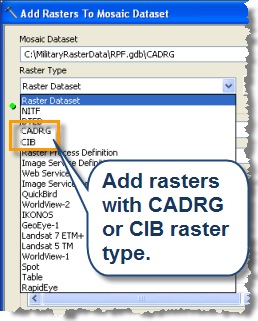 Once you’ve created the mosaic dataset you can add data with the Add Rasters To Mosaic Dataset tool. For CADRG or CIB data it is important to choose a raster type for the data you’re adding. This controls such things as what raster formats or products to add, and what metadata from the source raster to include in the mosaic dataset’s attribute table.
The generic raster type, Raster Datset, can be used to add any raster file format supported by ArcGIS. However, for CADRG or CIB data we highly recommend using the CADRG and CIB raster types, as they provide additional capabilities not offered by the Raster Dataset raster type. These include:
The CADRG and CIB raster types only handle these specific products so, for example, if you were adding data from a folder containing a mix of CADRG, CIB, and other raster formats and you selected the CADRG raster type when adding data, only CADRG raster datasets (any CADRG product) would be added to the mosaic dataset.
The CADRG and CIB raster types cause specific metadata to be extracted from each CADRG or CIB raster; the metadata is added as an attribute associated with the raster’s footprint in the mosaic dataset attribute table.
The CADRG and CIB raster types include update logic that handles duplicate datasets in a manner more appropriate for CADRG and CIB data (details in a future blog post).
Adding specific CADRG/CIB products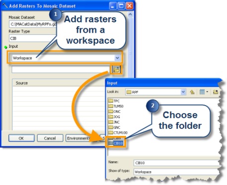 Sometimes you may only want certain CADRG or CIB products to be added to a mosaic dataset.
For example, you might have a folder of new CIB rasters that you want to use to update a mosaic dataset, or you may want to load just the Topographic Line Map (1:50,000) scale data into a mosaic dataset. In this case, you can specify which CADRG/CIB products to add.
There are three ways to do this:
You can limit the input workspaces to just those folders containing the CADRG or CIB products you want to add.
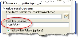 You can use the File Filter parameter on the Add Rasters To Mosaic Dataset tool to control which products are added based on file extensions.
For example, executing the tool with the file filter value shown here will add any Operational Navigation Chart (ONC) or Topographic Line Map 1:50,000 (TLM50) contained within the input workspace(s) to the mosaic dataset.
 You can select the specific CADRG or CIB products to add to the mosaic dataset using the Raster File Formats Properties dialog. To do this in ArcMap (or ArcGlobe and ArcScene) click the Customize menu, click ArcMap Options, click the Raster tab, click the Raster Dataset tab, then click File Formats. ArcMap will ignore rasters with other file extensions during the data loading process. You can tell ArcMap to display all raster formats when you have finished loading the data.
Building Pyramids and Raster Statistics
The Add Rasters To Mosaic Dataset tool provides the option to build raster pyramids and raster statistics on the source raster data while the data is being added to the mosaic dataset.
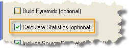
For CADRG and CIB data there is no need to build pyramids, it doesn’t provide any additional performance benefits.
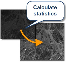 On the other hand, you should calculate raster statistics, because they’re required for some geoprocessing operations and rasters look better when statistics are calculated.
If you don’t calculate raster statistics when you add data to a mosaic dataset, you can calculate them later with the Build Pyramids and Statistics tool.
Storing rasters with multiple resolutions
CADRG and CIB raster formats have many different products of varying resolutions. Mosaic datasets let you store all CADRG or CIB products in a single mosaic dataset; as you zoom in and out of your map, the mosaic dataset draws the CADRG or CIB product that is applicable for that map scale (based on pixel size).
There are times when you may want to store some CADRG products in a separate mosaic dataset. For example, there are some CADRG products which share the same map scale (such as Topographic Line Map (1:50,000) and Combat Charts (1:50,000) or Joint Operations Graphic and VFR Terminal Area Chart). If these products are stored in the same mosaic dataset then you will run into the situation where only one product would draw for a given scale and area. One way to handle this is to store the CADRG products that have duplicate scales in separate mosaic datasets.


Do you need help in adding the right keywords to your CV? Let our CV writing experts help you.
